


51K - Cedar Air Park
Located in Olathe, United States
ICAO - 51K, IATA -
Data provided by AirmateGeneral information
Coordinates: N38°55'52" W94°53'5"
Elevation is 1024 feet MSL.
Magnetic variation is 05° East View others Airports in Kansas
Operational data
Special qualification required
Current time UTC:
Current local time:
Weather at : KIXD - New Century Aircenter ( 11 km )
METAR: KIXD 300553Z AUTO 16007KT 10SM CLR 15/10 A2990 RMK AO2 SLP118 T01500100 10228 20150 402390089 50003
TAF: KIXD 300520Z 3006/0106 16007KT P6SM SCT100 FM301500 18018G28KT P6SM SCT250 FM010100 20010KT P6SM VCTS BKN050CB FM010400 23007KT P6SM SCT050
Communications frequencies: [VIEW]
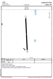
Runways:
| RWY identifier | QFU | Length (ft) | Width (ft) | Surface | LDA (ft) |
| 17 | 177° | 2440 | 75 | GRASS | |
| 35 | 357° | 2440 | 75 | GRASS |
Airport contact information
Address: Olathe United States