


3X5 - North Bass Island
Located in North Bass Island, United States
ICAO - 3X5, IATA -
Data provided by AirmateGeneral information
Coordinates: N41°43'5" W82°49'16"
Elevation is 594 feet MSL.
Magnetic variation is -06° East View others Airports in Ohio
Operational data
Special qualification required
Current time UTC:
Current local time:
Weather at : KPCW - Erie-Ottawa Intl ( 23 km )
METAR: KPCW 261415Z AUTO 11006KT 10SM CLR 11/02 A3026 RMK AO2
Communications frequencies: [VIEW]
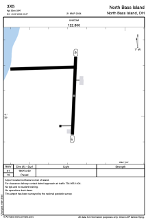
Runways:
| RWY identifier | QFU | Length (ft) | Width (ft) | Surface | LDA (ft) |
| 01 | 2° | 1804 | 60 | ASPH | |
| 19 | 182° | 1804 | 60 | ASPH |
Airport contact information
Address: North Bass Island United States