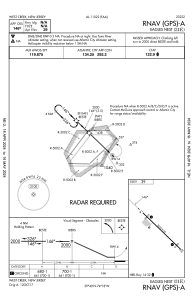


31E - Eagles Nest
Located in West Creek, United States
ICAO - 31E, IATA -
Data provided by AirmateGeneral information
Coordinates: N39°39'56" W74°18'29"
Elevation is 39 feet MSL.
Magnetic variation is -12° East View others Airports in New Jersey
Operational data
Special qualification required
Current time UTC:
Current local time:
Weather at : KMJX - Ocean County ( 29 km )
METAR: KMJX 261256Z AUTO VRB06KT 10SM CLR 09/02 A3048 RMK AO2 SLP326 T00940022
Communications frequencies: [VIEW]
Runways:
| RWY identifier | QFU | Length (ft) | Width (ft) | Surface | LDA (ft) |
| 14 | 134° | 3670 | 60 | ASPH | |
| 32 | 314° | 3670 | 60 | ASPH |
Airport contact information
Address: West Creek United States