


2H5 - Houston Fort Bend
Located in Houston, United States
ICAO - 2H5, IATA -
Data provided by AirmateGeneral information
Coordinates: N29°29'57" W95°53'54"
Elevation is 105 feet MSL.
View others Airports in Texas
Operational data
Special qualification required
Current time UTC:
Current local time:
Weather at : KSGR - Sugar Land Rgnl ( 27 km )
METAR: KSGR 292353Z 11008KT 10SM CLR 26/21 A2986 RMK AO2 SLP112 T02610211 10289 20261 55000
TAF: KSGR 292320Z 3000/3024 13008KT P6SM SCT025 BKN035 FM300500 VRB04KT P6SM FEW010 SCT025 FM300900 VRB03KT 4SM BR BKN010 FM301500 14005KT P6SM BKN015 FM301800 13009KT P6SM SCT030
Communications frequencies: [VIEW]
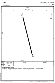
Runways:
| RWY identifier | QFU | Length (ft) | Width (ft) | Surface | LDA (ft) |
| 17 | 166° | 4400 | 100 | GRASS | |
| 35 | 346° | 4400 | 100 | GRASS |
Airport contact information
Address: Houston United States