


2H5 - Houston Fort Bend
Located in Houston, United States
ICAO - 2H5, IATA -
Data provided by AirmateGeneral information
Coordinates: N29°29'57" W95°53'54"
Elevation is 105 feet MSL.
View others Airports in Texas
Operational data
Special qualification required
Current time UTC:
Current local time:
Weather at : KSGR - Sugar Land Rgnl ( 27 km )
METAR: KSGR 261453Z 15015G19KT 10SM OVC022 25/22 A2987 RMK AO2 SLP118 T02500217 51009
TAF: KSGR 261125Z 2612/2712 15011KT P6SM SCT014 BKN019 OVC025 FM261500 16016G26KT P6SM BKN025 OVC150 FM261900 16016G26KT P6SM SCT025 BKN035 FM262300 16016G26KT P6SM BKN025 FM270200 15015KT P6SM OVC015
Communications frequencies: [VIEW]
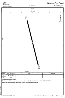
Runways:
| RWY identifier | QFU | Length (ft) | Width (ft) | Surface | LDA (ft) |
| 17 | 166° | 4400 | 100 | GRASS | |
| 35 | 346° | 4400 | 100 | GRASS |
Airport contact information
Address: Houston United States