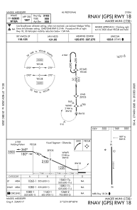
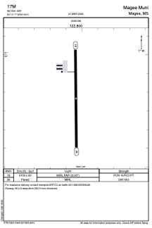


17M - Magee Muni
Located in Magee, United States
ICAO - 17M, IATA -
Data provided by AirmateGeneral information
Coordinates: N31°51'46" W89°48'2"
Elevation is 556 feet MSL.
Magnetic variation is -01° East View others Airports in Mississippi
Operational data
Special qualification required
Current time UTC:
Current local time:
Weather at : KJAN - Jackson-Medgar Wiley Evers Intl ( 56 km )
METAR: KJAN 291454Z 05004KT 10SM FEW042 BKN060 OVC110 19/18 A3000 RMK AO2 RAE53 SLP155 P0004 60018 T01940178 50003 $
TAF: KJAN 291246Z 2913/3012 23006KT 3SM RA OVC012 FM291330 16005KT P6SM -RA SCT040 OVC070 FM291700 17011G18KT P6SM OVC100 FM300400 19004KT P6SM OVC013 FM300800 VRB03KT P6SM OVC006
Communications frequencies: [VIEW]
Runways:
| RWY identifier | QFU | Length (ft) | Width (ft) | Surface | LDA (ft) |
| 18 | 179° | 3103 | 60 | ASPH | |
| 36 | 359° | 3103 | 60 | ASPH |
Airport contact information
Address: Magee United States