


09A - Butler/Choctaw County
Located in Butler, United States
ICAO - 09A, IATA -
Data provided by AirmateGeneral information
Coordinates: N32°7'10" W88°7'39"
Elevation is 134 feet MSL.
Magnetic variation is -03° East View others Airports in Alabama
Operational data
Special qualification required
Current time UTC:
Current local time:
Weather at : KDYA - Demopolis Rgnl ( 42 km )
METAR: KDYA 260255Z AUTO 00000KT 10SM CLR 19/16 A3005 RMK AO2 T01880162
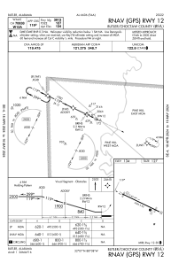
Communications frequencies: [VIEW]
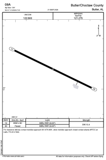
Runways:
| RWY identifier | QFU | Length (ft) | Width (ft) | Surface | LDA (ft) |
| 12 | 116° | 4082 | 80 | ASPH | |
| 30 | 296° | 4082 | 80 | ASPH |
Airport contact information
Address: Butler United States