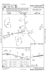
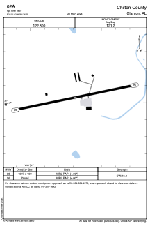


02A - Chilton County
Located in Clanton, United States
ICAO - 02A, IATA -
Data provided by AirmateGeneral information
Coordinates: N32°51'2" W86°36'41"
Elevation is 585 feet MSL.
Magnetic variation is -04° East View others Airports in Alabama
Operational data
Special qualification required
Current time UTC:
Current local time:
Weather at : KEET - Shelby County ( 40 km )
METAR: KEET 040153Z AUTO 19003KT 10SM BKN100 23/17 A2998 RMK AO2 LTG DSNT SW SLP145 T02330172
Communications frequencies: [VIEW]
Runways:
| RWY identifier | QFU | Length (ft) | Width (ft) | Surface | LDA (ft) |
| 08 | 78° | 4007 | 100 | ASPH | |
| 26 | 258° | 4007 | 100 | ASPH |
Airport contact information
Address: Clanton United States