


KPIR - Pierre Rgnl
Located in Pierre, United States
ICAO - PIR, IATA - PIR
Data provided by AirmateGeneral information
Coordinates: N44°22'58" W100°17'9"
Elevation is 1744 feet MSL.
Magnetic variation is 08° East View others Airports in South Dakota
Operational data
Special qualification required
Current time UTC:
Current local time:
Weather
TAF: KPIR 171131Z 1712/1812 VRB04KT 6SM SHRA BR VCTS SCT060CB OVC130 FM171400 08007KT P6SM VCTS OVC050CB FM171600 08013G22KT P6SM OVC017 FM180500 11009KT P6SM VCSH BKN006 WS020/17035KT FM180800 03008KT P6SM BKN007 WS020/18035KT FM181100 31011G19KT P6SM BKN011
Communications frequencies: [VIEW]
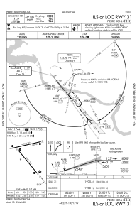
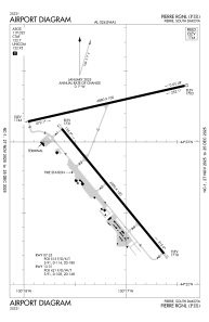
Runways:
| RWY identifier | QFU | Length (ft) | Width (ft) | Surface | LDA (ft) |
| 07 | 77° | 6880 | 150 | ASPH | 6830 |
| 25 | 257° | 6880 | 150 | ASPH | 6880 |
| 13 | 141° | 6900 | 100 | ASPH | 6900 |
| 31 | 321° | 6900 | 100 | ASPH | 6900 |
Airport contact information
Address: Pierre United States
