


KOTM - Ottumwa Rgnl
Located in Ottumwa, United States
ICAO - OTM, IATA - OTM
Data provided by AirmateGeneral information
Coordinates: N41°6'26" W92°26'50"
Elevation is 845 feet MSL.
Magnetic variation is -01° East View others Airports in Iowa
Operational data
Special qualification required
Current time UTC:
Current local time:
Communications frequencies: [VIEW]
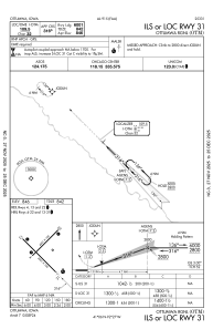
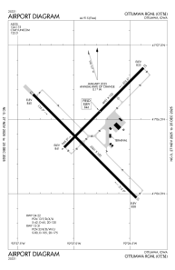
Runways:
| RWY identifier | QFU | Length (ft) | Width (ft) | Surface | LDA (ft) |
| 04 | 45° | 4601 | 100 | OTHER | |
| 22 | 225° | 4601 | 100 | OTHER | |
| 13 | 135° | 6001 | 100 | CONC | |
| 31 | 315° | 6001 | 100 | CONC |
Airport contact information
Address: Ottumwa United States
