


KDBQ - Dubuque Rgnl
Located in Dubuque, United States
ICAO - DBQ, IATA - DBQ
Data provided by AirmateGeneral information
Coordinates: N42°24'7" W90°42'34"
Elevation is 1076 feet MSL.
Magnetic variation is 03° East View others Airports in Iowa
Operational data
Special qualification required
Current time UTC:
Current local time:
Communications frequencies: [VIEW]
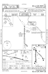
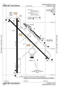
Runways:
| RWY identifier | QFU | Length (ft) | Width (ft) | Surface | LDA (ft) |
| 13 | 135° | 6502 | 100 | CONC | 6502 |
| 31 | 315° | 6502 | 100 | CONC | 6502 |
| 18 | 180° | 6327 | 150 | CONC | 6327 |
| 36 | 360° | 6327 | 150 | CONC | 6327 |
Airport contact information
Address: Dubuque United States