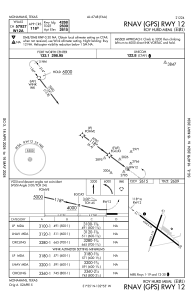
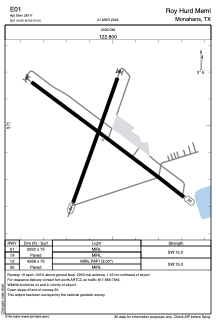


E01 - Roy Hurd Meml
Located in Monahans, United States
ICAO - E01, IATA -
Data provided by AirmateGeneral information
Coordinates: N31°34'57" W102°54'33"
Elevation is 2615 feet MSL.
Magnetic variation is 09° East View others Airports in Texas
Operational data
Special qualification required
Current time UTC:
Current local time:
Communications frequencies: [VIEW]
Runways:
| RWY identifier | QFU | Length (ft) | Width (ft) | Surface | LDA (ft) |
| 01 | 20° | 2922 | 75 | ASPH | |
| 19 | 200° | 2922 | 75 | ASPH | |
| 12 | 127° | 4268 | 75 | ASPH | |
| 30 | 307° | 4268 | 75 | ASPH |
Airport contact information
Address: Monahans United States