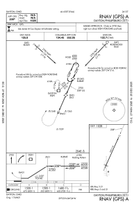
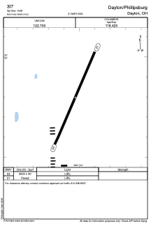


3I7 - Dayton/Phillipsburg
Located in Dayton, United States
ICAO - 3I7, IATA -
Data provided by AirmateGeneral information
Coordinates: N39°54'48" W84°24'1"
Elevation is 1028 feet MSL.
Magnetic variation is -04° East View others Airports in Ohio
Operational data
Special qualification required
Current time UTC:
Current local time:
Communications frequencies: [VIEW]
Runways:
| RWY identifier | QFU | Length (ft) | Width (ft) | Surface | LDA (ft) |
| 03 | 24° | 3000 | 40 | ASPH | |
| 21 | 204° | 3000 | 40 | ASPH |
Airport contact information
Address: Dayton United States
