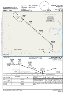
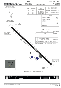


WAKJ - Merauke / Kimaam
Located in , Indonesia
ICAO - , IATA - KMM
Data provided by AirmateGeneral information
Coordinates: S7°58'45" E138°51'9"
Elevation is 14 feet MSL.
View others Airports in Papua
Operational data
Special qualification required
Current time UTC:
Current local time:
Weather at : - ( 0 km )
METAR: ZMUB 130600Z 34009MPS 310V010 9999 FEW033 SCT100 11/M00 Q1018 NOSIG RMK QFE655.9 44 MOP
Communications frequencies: [VIEW]
Runways:
| RWY identifier | QFU | Length (ft) | Width (ft) | Surface | LDA (ft) |
| 13 | 131° | 3018 | 75 | UNK | |
| 31 | 311° | 3018 | 75 | UNK |
Airport contact information
Address: Indonesia