


T54 - Lane Airpark
Located in Rosenberg, United States
ICAO - T54, IATA -
Data provided by AirmateGeneral information
Coordinates: N29°31'24" W95°46'47"
Elevation is 94 feet MSL.
Magnetic variation is 05° East View others Airports in Texas
Operational data
Special qualification required
Current time UTC:
Current local time:
Weather at : KSGR - Sugar Land Rgnl ( 16 km )
METAR: KSGR 190253Z AUTO 15007KT 10SM CLR 27/24 A2988 RMK AO2 SLP120 T02670239 53017
TAF: KSGR 182320Z 1900/1924 11008KT P6SM BKN040 FM190500 VRB03KT 6SM BR FEW010 BKN020 TEMPO 1908/1912 1SM BR OVC004 FM191500 13007KT P6SM SCT250
Communications frequencies: [VIEW]
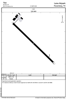
Runways:
| RWY identifier | QFU | Length (ft) | Width (ft) | Surface | LDA (ft) |
| 13 | 0° | 2890 | 35 | ASPH | |
| 31 | 0° | 2890 | 35 | ASPH |
Airport contact information
Address: Rosenberg United States