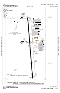


KSGR - Sugar Land Rgnl
Located in Houston, United States
ICAO - SGR, IATA -
Data provided by AirmateGeneral information
Coordinates: N29°37'20" W95°39'24"
Elevation is 81 feet MSL.
Magnetic variation is 05° East View others Airports in Texas
Operational data
Special qualification required
Current time UTC:
Current local time:
Weather
METAR: KSGR 282253Z 15013G21KT 7SM OVC015 26/24 A2978 RMK AO2 SLP084 T02610239
TAF: KSGR 282041Z 2821/2918 14016G26KT P6SM VCSH SCT022 OVC026 TEMPO 2821/2823 4SM SHRA FM290000 16014KT P6SM VCSH SCT008 OVC012 FM290300 16013KT P6SM VCTS SCT008 OVC012CB TEMPO 2904/2907 -TSRA BKN008CB FM291000 23007KT P6SM VCSH SCT008 BKN015 FM291600 23006KT P6SM SCT015 BKN025
Communications frequencies: [VIEW]
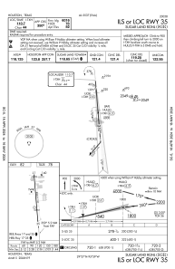
Runways:
| RWY identifier | QFU | Length (ft) | Width (ft) | Surface | LDA (ft) |
| 17 | 175° | 8000 | 100 | CONC | |
| 35 | 355° | 8000 | 100 | CONC |
Airport contact information
Address: Houston United States
