


S35 - Okanogan Legion
Located in Okanogan, United States
ICAO - S35, IATA -
Data provided by AirmateGeneral information
Coordinates: N48°21'43" W119°34'3"
Elevation is 1042 feet MSL.
Magnetic variation is 20° East View others Airports in Washington
Operational data
Special qualification required
Current time UTC:
Current local time:
Weather at : KOMK - Omak ( 12 km )
METAR: KOMK 301953Z AUTO 00000KT 10SM CLR 13/M07 A3000 RMK AO2 SLP163 T01281067
Communications frequencies: [VIEW]
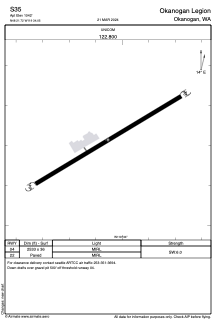
Runways:
| RWY identifier | QFU | Length (ft) | Width (ft) | Surface | LDA (ft) |
| 04 | 0° | 2533 | 36 | ASPH | |
| 22 | 0° | 2533 | 36 | ASPH |
Airport contact information
Address: Okanogan United States