


S03 - Ashland Muni/Sumner Parker Fld
Located in Ashland, United States
ICAO - S03, IATA -
Data provided by AirmateGeneral information
Coordinates: N42°11'25" W122°39'38"
Elevation is 1889 feet MSL.
Magnetic variation is 18° East View others Airports in Oregon
Operational data
Special qualification required
Current time UTC:
Current local time:
Weather at : KMFR - Rogue Valley Intl - Medford ( 27 km )
METAR: KMFR 210853Z AUTO 00000KT 10SM CLR 10/02 A3018 RMK AO2 SLP216 T01000017 50003
TAF: KMFR 210520Z 2106/2206 VRB02KT P6SM SKC FM212200 32005KT P6SM FEW250 FM220000 33008KT P6SM BKN100
Communications frequencies: [VIEW]
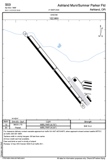
Runways:
| RWY identifier | QFU | Length (ft) | Width (ft) | Surface | LDA (ft) |
| 12 | 141° | 3603 | 75 | ASPH | |
| 30 | 321° | 3603 | 75 | ASPH |
Airport contact information
Address: Ashland United States
