


KMFR - Rogue Valley Intl - Medford
Located in Medford, United States
ICAO - MFR, IATA - MFR
Data provided by AirmateGeneral information
Coordinates: N42°22'30" W122°52'24"
Elevation is 1335 feet MSL.
Magnetic variation is 16° East View others Airports in Oregon
Operational data
Special qualification required
Current time UTC:
Current local time:
Weather
METAR: KMFR 291553Z 32008KT 10SM BKN039 OVC048 08/03 A3018 RMK AO2 SLP221 T00830028
TAF: KMFR 291129Z 2912/3012 30007KT P6SM FEW050 FM292000 33014KT P6SM VCSH SCT040 BKN070 FM300500 34005KT P6SM SCT080
Communications frequencies: [VIEW]
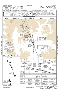
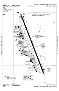
Runways:
| RWY identifier | QFU | Length (ft) | Width (ft) | Surface | LDA (ft) |
| 14 | 158° | 8800 | 150 | ASPH | 8800 |
| 32 | 338° | 8800 | 150 | ASPH | 8800 |
Airport contact information
Address: Medford United States