


PAYA - Yakutat
Located in Yakutat,
ICAO - YAK, IATA - YAK
Data provided by AirmateGeneral information
Coordinates: N59°30'12" W139°39'37"
Elevation is 40 feet MSL.
Magnetic variation is 20° East View others Airports in Alaska
Operational data
Special qualification required
Current time UTC:
Current local time:
Weather
METAR: PAYA 050353Z AUTO 07004KT 4SM -RA BR SCT024 BKN033 OVC041 09/07 A2951 RMK AO2 SLP993 P0005 T00890072 TSNO $
TAF: PAYA 042326Z 0500/0524 12007KT 4SM -RA SCT007 BKN015 OVC030 FM050600 11005KT 2SM -RA BR OVC007 AMD LTD TO CLD VIS AND WIND
Communications frequencies: [VIEW]
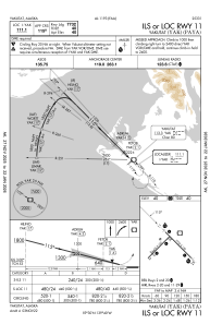
Runways:
| RWY identifier | QFU | Length (ft) | Width (ft) | Surface | LDA (ft) |
| 02 | 45° | 6475 | 150 | CONC | 5087 |
| 20 | 225° | 6475 | 150 | CONC | 6475 |
| 11 | 135° | 7732 | 150 | ASPH | |
| 29 | 315° | 7732 | 150 | ASPH |
Airport contact information
Address: Yakutat