


PASD - Sand Point
Located in Sand Point,
ICAO - SDP, IATA - SDP
Data provided by AirmateGeneral information
Coordinates: N55°18'49" W160°31'17"
Elevation is 24 feet MSL.
Magnetic variation is 11° East View others Airports in Alaska
Operational data
Special qualification required
Current time UTC:
Current local time:
Weather
METAR: PASD 050556Z AUTO 30011G20KT 10SM BKN019 BKN025 04/01 A2940 RMK AO2 RAE00 SLP958 6//// T00390011 10061 20039 53019 PNO $
TAF: PASD 050521Z 0506/0606 29012KT P6SM -RA OVC030 FM051200 31015KT P6SM VCSH BKN030 FM051800 31015G25KT P6SM VCSH OVC025 FM060300 30012KT P6SM OVC035
Communications frequencies: [VIEW]
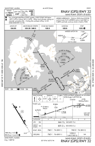
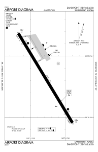
Runways:
| RWY identifier | QFU | Length (ft) | Width (ft) | Surface | LDA (ft) |
| 14 | 148° | 5213 | 150 | ASPH | 4099 |
| 32 | 328° | 5213 | 150 | ASPH | 4099 |
Airport contact information
Address: Sand Point