


PASD - Sand Point
Located in Sand Point,
ICAO - SDP, IATA - SDP
Data provided by AirmateGeneral information
Coordinates: N55°18'49" W160°31'17"
Elevation is 24 feet MSL.
Magnetic variation is 11° East View others Airports in Alaska
Operational data
Special qualification required
Current time UTC:
Current local time:
Weather
METAR: PASD 031656Z VRB04KT 3SM -SNRA BR SCT010 BKN018 OVC022 02/00 A2936 RMK AO2 SLP944 T00170000 PNO $
TAF: PASD 031130Z 0312/0412 16010KT P6SM BKN030 OVC050 FM031400 15010G20KT 4SM -RA BR BKN015 OVC025 FM040200 22013KT P6SM SCT015 OVC030
Communications frequencies: [VIEW]
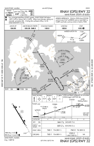
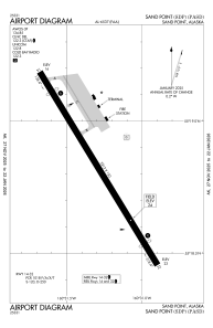
Runways:
| RWY identifier | QFU | Length (ft) | Width (ft) | Surface | LDA (ft) |
| 14 | 148° | 5213 | 150 | ASPH | 4099 |
| 32 | 328° | 5213 | 150 | ASPH | 4099 |
Airport contact information
Address: Sand Point