


PABG - Beluga
Located in Beluga,
ICAO - BLG, IATA - BVU
Data provided by AirmateGeneral information
Coordinates: N61°10'23" W151°2'43"
Elevation is 87 feet MSL.
Magnetic variation is 19° East View others Airports in Alaska
Operational data
Special qualification required
Current time UTC:
Current local time:
Weather at : PANC - Ted Stevens Anchorage Intl ( 56 km )
METAR: PANC 080153Z 16015G24KT 10SM FEW050 BKN100 BKN150 08/01 A2963 RMK AO2 PK WND 17027/0133 SLP036 SH DSNT N T00830011
TAF: PANC 072324Z 0800/0906 16012G20KT P6SM VCSH BKN080 FM080500 15008KT P6SM SCT080 BKN120 FM081200 34004KT P6SM FEW080 SCT120 FM090100 23007KT P6SM -RA SCT045 BKN060
Communications frequencies: [VIEW]
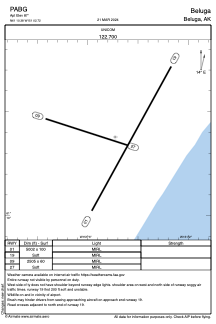
Runways:
| RWY identifier | QFU | Length (ft) | Width (ft) | Surface | LDA (ft) |
| 01 | 29° | 5002 | 100 | GRAVEL | |
| 19 | 209° | 5002 | 100 | GRAVEL | |
| 09 | 108° | 2505 | 60 | GRAVEL | |
| 27 | 288° | 2505 | 60 | GRAVEL |
Airport contact information
Address: Beluga