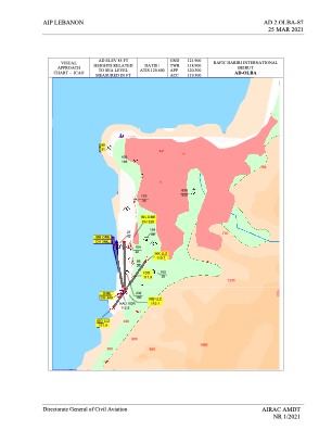
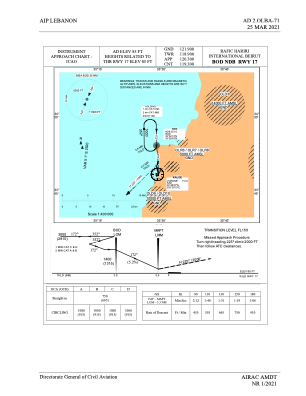
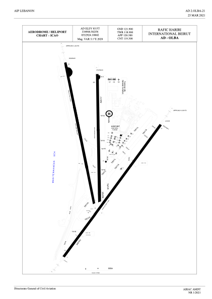


OLBA - Rafic Hariri International Beirut
Located in Beirut, Lebanon
ICAO - OLBA, IATA - BEY
Data provided by AirmateGeneral information
Coordinates: N33°49'9" E35°29'24"
Elevation is 85 feet MSL.
View others Airports in Mount Lebanon Governorate
Operational data
Special qualification required
Current time UTC:
Current local time:
Weather
METAR: OLBA 190400Z 12005KT 7000 NSC 21/12 Q1014 NOSIG
TAF: TAF OLBA 190400Z 1906/2012 31005KT 7000 SCT070 BECMG 1909/1912 VRB02KT BECMG 1918/1921 28005KT BECMG 1921/1924 VRB02KT BECMG 2003/2006 20005KT BECMG 2009/2012 01005KT BKN200
Communications frequencies: [VIEW]
Runways:
| RWY identifier | QFU | Length (ft) | Width (ft) | Surface | LDA (ft) |
| 03 | 33° | 12467 | 148 | CON | |
| 21 | 213° | 12467 | 148 | CON | |
| 16 | 167° | 11138 | 148 | CON | |
| 34 | 347° | 11138 | 148 | CON | |
| 17 | 177° | 10663 | 148 | ASP | |
| 35 | 357° | 10663 | 148 | ASP |
Airport contact information
Address: Beirut Lebanon