


OG31 - Shady Cove Airpark
Located in Shady Cove, United States
ICAO - OG31, IATA -
Data provided by AirmateGeneral information
Coordinates: N42°36'31" W122°49'46"
Elevation is 1522 feet MSL.
Magnetic variation is 18° East View others Airports in Oregon
Operational data
Special qualification required
Current time UTC:
Current local time:
Weather at : KMFR - Rogue Valley Intl - Medford ( 26 km )
TAF: KMFR 210520Z 2106/2206 VRB02KT P6SM SKC FM212200 32005KT P6SM FEW250 FM220000 33008KT P6SM BKN100
Communications frequencies: [VIEW]
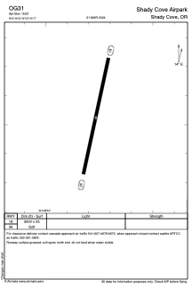
Runways:
| RWY identifier | QFU | Length (ft) | Width (ft) | Surface | LDA (ft) |
| 18 | 0° | 2600 | 25 | OTHER | |
| 36 | 0° | 2600 | 25 | OTHER |
Airport contact information
Address: Shady Cove United States