


O45 - Hooker Muni
Located in Hooker, United States
ICAO - O45, IATA -
Data provided by AirmateGeneral information
Coordinates: N36°51'25" W101°13'38"
Elevation is 3000 feet MSL.
Magnetic variation is 09° East View others Airports in Oklahoma
Operational data
Special qualification required
Current time UTC:
Current local time:
Weather at : KGUY - Guymon Muni ( 31 km )
METAR: KGUY 032353Z AUTO 17014G24KT 10SM FEW050 23/13 A2977 RMK AO2 PK WND 16029/2338 LTG DSNT NW SLP045 T02330133 10261 20206 56020
TAF: KGUY 032322Z 0400/0424 16010G20KT P6SM SCT045 FM040300 17012KT P6SM BKN060 WS020/20040KT FM040800 36019G29KT 6SM -SHRA BR BKN015 PROB30 0408/0411 36025G40KT 3SM -TSRA BKN015CB FM041700 04012G22KT P6SM SCT040 FM042000 06010KT P6SM SCT050
Communications frequencies: [VIEW]
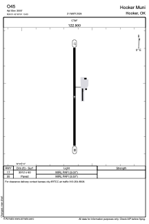
Runways:
| RWY identifier | QFU | Length (ft) | Width (ft) | Surface | LDA (ft) |
| 17 | 180° | 3312 | 60 | ASPH | |
| 35 | 360° | 3312 | 60 | ASPH |
Airport contact information
Address: Hooker United States