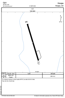


O21 - Hoopa
Located in Hoopa, United States
ICAO - O21, IATA -
Data provided by AirmateGeneral information
Coordinates: N41°2'29" W123°40'4"
Elevation is 356 feet MSL.
Magnetic variation is 17° East View others Airports in California
Operational data
Special qualification required
Current time UTC:
Current local time:
Weather at : KACV - California Redwood Coast-Humboldt County ( 38 km )
METAR: KACV 260614Z AUTO 21004KT 1 3/4SM RA BR OVC003 10/10 A3004 RMK AO2 P0004 T01000100
TAF: KACV 260521Z 2606/2706 19006KT 2SM -SHRA BKN007 OVC015 FM261100 27007KT 5SM -SHRA BKN007 OVC015 FM261500 28007KT 5SM -SHRA BKN015 OVC035 FM261900 32013KT 6SM BR VCSH SCT015 OVC040 FM270400 32011KT P6SM SCT015 OVC040
Communications frequencies: [VIEW]
Runways:
| RWY identifier | QFU | Length (ft) | Width (ft) | Surface | LDA (ft) |
| 14 | 0° | 2325 | 50 | ASPH | |
| 32 | 0° | 2325 | 50 | ASPH |
Airport contact information
Address: Hoopa United States