


NSTU - Pago Pago Intl
Located in Pago Pago, Samoa
ICAO - PPG, IATA - PPG
Data provided by AirmateGeneral information
Coordinates: S14°19'54" W170°42'41"
Elevation is 31 feet MSL.
Magnetic variation is 12° East View others Airports in (unassigned)
Operational data
Special qualification required
Current time UTC:
Current local time:
Weather
METAR: NSTU 191750Z 10013KT 12SM FEW015TCU SCT040 BKN100 28/26 A2986 RMK SHRAE30 TCU W-N SLP113 60018 8/870 T02820258 10284 20270 52008
TAF: NSTU 191735Z 1918/2018 09012KT P6SM VCSH SCT020 BKN035 FM192000 09013KT P6SM VCSH SCT020 SCT040
Communications frequencies: [VIEW]
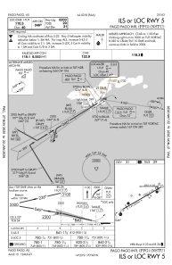
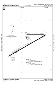
Runways:
| RWY identifier | QFU | Length (ft) | Width (ft) | Surface | LDA (ft) |
| 05 | 60° | 10001 | 150 | ASPH | 8200 |
| 23 | 240° | 10001 | 150 | ASPH | 9200 |
| 08 | 90° | 3801 | 100 | ASPH | |
| 26 | 270° | 3801 | 100 | ASPH |
Airport contact information
Address: Pago Pago Samoa