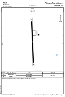


M59 - Richton-Perry County
Located in Richton, United States
ICAO - M59, IATA -
Data provided by AirmateGeneral information
Coordinates: N31°19'1" W88°56'6"
Elevation is 167 feet MSL.
Magnetic variation is 02° East View others Airports in Mississippi
Operational data
Special qualification required
Current time UTC:
Current local time:
Weather at : KHBG - Hattiesburg Bobby L Chain Muni ( 31 km )
METAR: KHBG 082353Z AUTO 18009KT 10SM CLR 29/22 A2975 RMK AO2 SLP070 T02940222 10322 20294 56007
TAF: KHBG 082347Z 0900/0924 18012KT P6SM FEW040 FM090400 18008KT P6SM SCT009 BKN015 OVC025 FM091600 25008KT P6SM BKN040
Communications frequencies: [VIEW]
Runways:
| RWY identifier | QFU | Length (ft) | Width (ft) | Surface | LDA (ft) |
| 18 | 178° | 3000 | 60 | ASPH | |
| 36 | 358° | 3000 | 60 | ASPH |
Airport contact information
Address: Richton United States