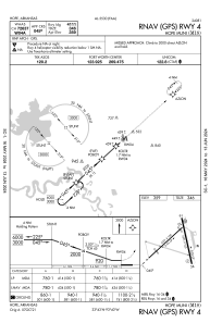


M18 - Hope Muni
Located in Hope, United States
ICAO - M18, IATA -
Data provided by AirmateGeneral information
Coordinates: N33°43'12" W93°39'32"
Elevation is 359 feet MSL.
Magnetic variation is 03° East View others Airports in Arkansas
Operational data
Special qualification required
Current time UTC:
Current local time:
Weather at : KTXK - Texarkana Rgnl-Webb Fld ( 43 km )
METAR: KTXK 090153Z 18010KT 5SM HZ FEW039 28/24 A2959 RMK AO2 SLP014 T02780239
TAF: KTXK 082335Z 0900/0924 18009KT 3SM HZ FEW025 OVC035 FM090300 19008KT P6SM VCTS BKN040CB FM090400 VRB25G35KT 2SM +TSRA BR OVC025CB FM090700 VRB05KT P6SM SCT070 BKN090 FM091200 VRB03KT P6SM BKN020 FM091600 06006KT P6SM BKN035
Communications frequencies: [VIEW]
Runways:
| RWY identifier | QFU | Length (ft) | Width (ft) | Surface | LDA (ft) |
| 04 | 48° | 5301 | 100 | CONC | |
| 22 | 228° | 5301 | 100 | CONC | |
| 16 | 167° | 5501 | 100 | CONC | |
| 34 | 347° | 5501 | 100 | CONC |
Airport contact information
Address: Hope United States