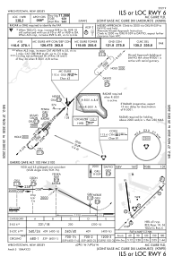
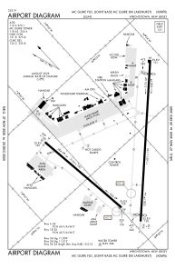


KWRI - Mc Guire Fld (Joint Base Mc Guire Dix Lakehurst)
Located in Wrightstown, United States
ICAO - WRI, IATA - WRI
Data provided by AirmateGeneral information
Coordinates: N40°0'56" W74°35'30"
Elevation is 140 feet MSL.
Magnetic variation is -12° East View others Airports in New Jersey
Operational data
Special qualification required
Current time UTC:
Current local time:
Weather
METAR: KWRI 082055Z AUTO 28009KT 10SM CLR 30/13 A2955 RMK AO2 SLP005 T02980127 55007 TSNO $
TAF: TAF KWRI 081800Z 0818/0924 26012G22KT 9999 SCT035 QNH2956INS BECMG 0822/0823 25009KT 9999 FEW050 SCT250 QNH2959INS BECMG 0906/0907 VRB03KT 9999 SCT080 BKN220 QNH2967INS BECMG 0913/0914 06008KT 6000 -SHRA BKN012 QNH2969INS BECMG 0920/0921 06005KT 4800 -SHRA BKN009 QNH2967INS TX30/0820Z TN14/0910Z
Communications frequencies: [VIEW]
Runways:
| RWY identifier | QFU | Length (ft) | Width (ft) | Surface | LDA (ft) |
| 06 | 45° | 10014 | 150 | OTHER | |
| 24 | 225° | 10014 | 150 | OTHER | |
| 18 | 173° | 7126 | 150 | CONC | |
| 36 | 353° | 7126 | 150 | CONC |
Airport contact information
Address: Wrightstown United States