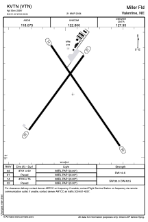


KVTN - Miller Fld
Located in Valentine, United States
ICAO - VTN, IATA -
Data provided by AirmateGeneral information
Coordinates: N42°51'24" W100°32'56"
Elevation is 2595 feet MSL.
Magnetic variation is 08° East View others Airports in Nebraska
Operational data
Special qualification required
Current time UTC:
Current local time:
Weather
TAF: KVTN 040538Z 0406/0506 30006KT P6SM SCT006 OVC060 FM040800 29006KT P6SM SKC FM041800 33007KT P6SM SKC FM042300 12006KT P6SM SKC
Communications frequencies: [VIEW]
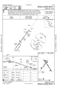
Runways:
| RWY identifier | QFU | Length (ft) | Width (ft) | Surface | LDA (ft) |
| 03 | 36° | 3701 | 60 | CONC | |
| 21 | 216° | 3701 | 60 | CONC | |
| 14 | 145° | 4704 | 75 | CONC | |
| 32 | 325° | 4704 | 75 | CONC |
Airport contact information
Address: Valentine United States
