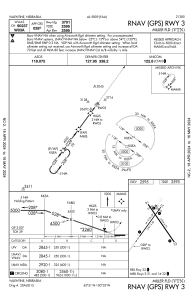
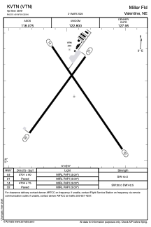


KVTN - Miller Fld
Located in Valentine, United States
ICAO - VTN, IATA -
Data provided by AirmateGeneral information
Coordinates: N42°51'24" W100°32'56"
Elevation is 2595 feet MSL.
Magnetic variation is 08° East View others Airports in Nebraska
Operational data
Special qualification required
Current time UTC:
Current local time:
Weather
METAR: KVTN 051152Z AUTO 16005KT 10SM CLR 05/03 A2996 RMK AO2 SLP149 T00500028 10083 20044 56008
TAF: KVTN 051122Z 0512/0612 16010KT P6SM SKC FM051400 17019G29KT P6SM FEW250 FM051800 16028G39KT P6SM BKN045 FM060100 14022G35KT P6SM BKN045 FM060600 15023G37KT P6SM OVC015 WS015/17045KT FM061000 15027G40KT P6SM OVC007 WS015/17045KT
Communications frequencies: [VIEW]
Runways:
| RWY identifier | QFU | Length (ft) | Width (ft) | Surface | LDA (ft) |
| 03 | 36° | 3701 | 60 | CONC | |
| 21 | 216° | 3701 | 60 | CONC | |
| 14 | 145° | 4704 | 75 | CONC | |
| 32 | 325° | 4704 | 75 | CONC |
Airport contact information
Address: Valentine United States
