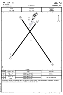


KVTN - Miller Fld
Located in Valentine, United States
ICAO - VTN, IATA -
Data provided by AirmateGeneral information
Coordinates: N42°51'24" W100°32'56"
Elevation is 2595 feet MSL.
Magnetic variation is 08° East View others Airports in Nebraska
Operational data
Special qualification required
Current time UTC:
Current local time:
Weather
METAR: KVTN 030052Z AUTO 28013G23KT 10SM CLR 16/M10 A2986 RMK AO2 PK WND 28031/0031 SLP112 T01561100
TAF: KVTN 022320Z 0300/0324 26014G22KT P6SM SCT120 FM030200 24006KT P6SM SCT200 FM031000 01006KT P6SM BKN100 FM031500 04010KT P6SM VCSH BKN070 OVC100 FM031800 01012KT P6SM VCSH OVC050 FM032100 01015G24KT 5SM -SHRA VCTS BKN025 OVC050CB PROB30 0322/0324 2SM -TSRA OVC025CB
Communications frequencies: [VIEW]
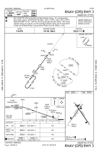
Runways:
| RWY identifier | QFU | Length (ft) | Width (ft) | Surface | LDA (ft) |
| 03 | 36° | 3701 | 60 | CONC | |
| 21 | 216° | 3701 | 60 | CONC | |
| 14 | 145° | 4704 | 75 | CONC | |
| 32 | 325° | 4704 | 75 | CONC |
Airport contact information
Address: Valentine United States
