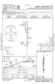
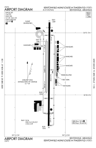


KVBT - Bentonville Muni/Louise M Thaden Fld
Located in Bentonville, United States
ICAO - VBT, IATA -
Data provided by AirmateGeneral information
Coordinates: N36°20'43" W94°13'10"
Elevation is 1298 feet MSL.
Magnetic variation is 01° East View others Airports in Arkansas
Operational data
Special qualification required
Current time UTC:
Current local time:
Weather
METAR: KVBT 070810Z AUTO 14007KT 10SM FEW018 SCT023 BKN060 17/17 A2962 RMK AO2 LTG DSNT E-SW TSE10RAE01 P0000 $
Communications frequencies: [VIEW]
Runways:
| RWY identifier | QFU | Length (ft) | Width (ft) | Surface | LDA (ft) |
| 17 | 180° | 2448 | 75 | GRASS | |
| 35 | 0° | 2448 | 75 | GRASS | |
| 18 | 180° | 4426 | 75 | ASPH | 4196 |
| 36 | 0° | 4426 | 75 | ASPH | 4196 |
Airport contact information
Address: Bentonville United States
