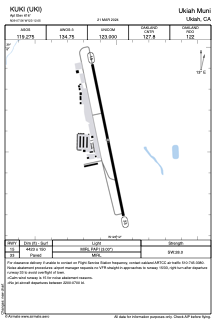


KUKI - Ukiah Muni
Located in Ukiah, United States
ICAO - UKI, IATA -
Data provided by AirmateGeneral information
Coordinates: N39°7'33" W123°12'3"
Elevation is 616 feet MSL.
Magnetic variation is 13° East View others Airports in California
Operational data
Special qualification required
Current time UTC:
Current local time:
Weather
METAR: KUKI 260556Z AUTO 36003KT 10SM OVC034 13/07 A3006 RMK AO2 SLP176 T01280072 10167 20122 50007
TAF: KUKI 260521Z 2606/2706 34005KT 6SM BR VCSH SCT035 OVC050 FM260800 34004KT 5SM BR VCSH BKN015 OVC020 FM261600 32008G18KT P6SM BKN030 OVC060 FM262100 31012G28KT P6SM SCT050 FM270500 36006KT P6SM SKC
Communications frequencies: [VIEW]
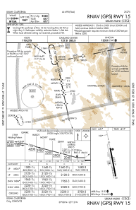
Runways:
| RWY identifier | QFU | Length (ft) | Width (ft) | Surface | LDA (ft) |
| 15 | 168° | 4423 | 150 | ASPH | |
| 33 | 348° | 4423 | 150 | ASPH |
Airport contact information
Address: Ukiah United States
