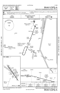


KTCS - Truth Or Consequences Muni
Located in Truth Or Consequences, United States
ICAO - TCS, IATA - TCS
Data provided by AirmateGeneral information
Coordinates: N33°14'7" W107°16'12"
Elevation is 4861 feet MSL.
Magnetic variation is 13° East View others Airports in New Mexico
Operational data
Special qualification required
Current time UTC:
Current local time:
Weather
METAR: KTCS 271453Z AUTO 23010G16KT 10SM CLR 14/M03 A2983 RMK AO2 SLP038 T01391033 51009 $
TAF: KTCS 271121Z 2712/2812 23012G20KT P6SM SKC FM271500 23014G24KT P6SM SCT080 FM271900 24020G30KT P6SM FEW150 FM280300 29010G20KT P6SM SKC
Communications frequencies: [VIEW]
Runways:
| RWY identifier | QFU | Length (ft) | Width (ft) | Surface | LDA (ft) |
| 01 | 21° | 3302 | 130 | GRAVEL | |
| 19 | 201° | 3302 | 130 | GRAVEL | |
| 07 | 79° | 2933 | 130 | GRAVEL | |
| 25 | 259° | 2933 | 130 | GRAVEL | |
| 11 | 125° | 6981 | 190 | GRAVEL | |
| 29 | 305° | 6981 | 190 | GRAVEL | |
| 13 | 145° | 7202 | 75 | ASPH | |
| 31 | 325° | 7202 | 75 | ASPH | |
| 15 | 167° | 3001 | 140 | GRAVEL | |
| 33 | 347° | 3001 | 140 | GRAVEL |
Airport contact information
Address: Truth Or Consequences United States