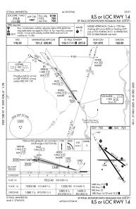
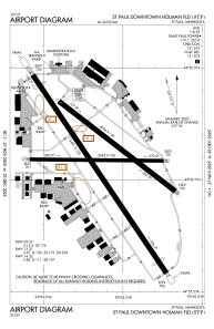


KSTP - St Paul Downtown Holman Fld
Located in St Paul, United States
ICAO - STP, IATA - STP
Data provided by AirmateGeneral information
Coordinates: N44°56'5" W93°3'37"
Elevation is 705 feet MSL.
Magnetic variation is 00° East View others Airports in Minnesota
Operational data
Special qualification required
Current time UTC:
Current local time:
Weather
METAR: KSTP 071101Z 17008KT 2 1/2SM +RA BR FEW009 BKN022 OVC029 14/13 A2944 RMK AO2 P0005 T01390133
Communications frequencies: [VIEW]
Runways:
| RWY identifier | QFU | Length (ft) | Width (ft) | Surface | LDA (ft) |
| 09 | 91° | 3642 | 100 | ASPH | 3642 |
| 27 | 271° | 3642 | 100 | ASPH | 3642 |
| 13 | 128° | 4004 | 150 | ASPH | 4004 |
| 31 | 308° | 4004 | 150 | ASPH | 4004 |
| 14 | 146° | 6491 | 150 | ASPH | 6148 |
| 32 | 326° | 6491 | 150 | ASPH | 6109 |
Airport contact information
Address: St Paul United States
