


KSLI - Los Alamitos Aaf
Located in Los Alamitos, United States
ICAO - SLI, IATA -
Data provided by AirmateGeneral information
Coordinates: N33°47'24" W118°3'5"
Elevation is 35 feet MSL.
Magnetic variation is 12° East View others Airports in California
Operational data
Special qualification required
Current time UTC:
Current local time:
Weather
METAR: KSLI 270455Z AUTO 17005KT 8SM CLR 15/11 A2985 RMK AO2 SLP111 T01460106
TAF: TAF KSLI 262100Z 2621/2803 25009KT 9999 FEW035 QNH2990INS BECMG 2700/2701 27012G18KT 9999 SKC QNH2980INS BECMG 2709/2710 28005KT 9999 SKC QNH2985INS TX21/2721Z TN14/2712Z
Communications frequencies: [VIEW]
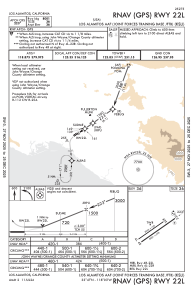
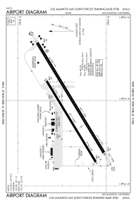
Runways:
| RWY identifier | QFU | Length (ft) | Width (ft) | Surface | LDA (ft) |
| 04R | 0° | 7999 | 200 | OTHER | |
| 22L | 0° | 7999 | 200 | OTHER | |
| 04L | 0° | 5901 | 150 | OTHER | |
| 22R | 0° | 5901 | 150 | OTHER |
Airport contact information
Address: Los Alamitos United States