


KSLI - Los Alamitos Aaf
Located in Los Alamitos, United States
ICAO - SLI, IATA -
Data provided by AirmateGeneral information
Coordinates: N33°47'24" W118°3'5"
Elevation is 35 feet MSL.
Magnetic variation is 12° East View others Airports in California
Operational data
Special qualification required
Current time UTC:
Current local time:
Weather
METAR: KSLI 250725Z AUTO 27005KT 9SM FEW022 SCT028 OVC035 14/11 A3003 RMK AO2 SLP172 $
TAF: TAF KSLI 242100Z 2421/2603 23009KT 9999 SCT025 SCT040 QNH3001INS BECMG 2503/2504 26012KT 9999 OVC025 QNH3003INS BECMG 2513/2514 VRB06KT 8000 BR BKN004 OVC011 QNH3005INS BECMG 2517/2518 VRB06KT 8000 BR SCT005 OVC011 QNH3001INS TX19/2422Z TN12/2514Z
Communications frequencies: [VIEW]
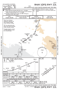
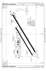
Runways:
| RWY identifier | QFU | Length (ft) | Width (ft) | Surface | LDA (ft) |
| 04R | 0° | 7999 | 200 | OTHER | |
| 22L | 0° | 7999 | 200 | OTHER | |
| 04L | 0° | 5901 | 150 | OTHER | |
| 22R | 0° | 5901 | 150 | OTHER |
Airport contact information
Address: Los Alamitos United States