
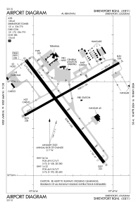


KSHV - Shreveport Rgnl
Located in Shreveport, United States
ICAO - SHV, IATA - SHV
Data provided by AirmateGeneral information
Coordinates: N32°26'47" W93°49'34"
Elevation is 257 feet MSL.
Magnetic variation is 02° East View others Airports in Louisiana
Operational data
Special qualification required
Current time UTC:
Current local time:
Weather
METAR: KSHV 022156Z 20007KT 10SM SCT027 BKN035 BKN240 27/20 A2978 RMK SLPNO
TAF: KSHV 021750Z 0218/0318 13011KT P6SM BKN014 OVC035 FM030000 17007KT P6SM OVC050 FM030600 VRB03KT 6SM BR VCSH OVC007 FM031000 17003KT 2SM -TSRA BR OVC007CB FM031500 29003KT 4SM -SHRA BR OVC007
Communications frequencies: [VIEW]
Runways:
| RWY identifier | QFU | Length (ft) | Width (ft) | Surface | LDA (ft) |
| 06 | 61° | 7003 | 150 | ASPH | 7003 |
| 24 | 241° | 7003 | 150 | ASPH | 7003 |
| 14 | 143° | 8348 | 200 | ASPH | 8118 |
| 32 | 323° | 8348 | 200 | ASPH | 7975 |
Airport contact information
Address: Shreveport United States