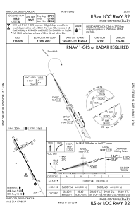
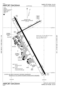


KRAP - Rapid City Rgnl
Located in Rapid City, United States
ICAO - RAP, IATA - RAP
Data provided by AirmateGeneral information
Coordinates: N44°2'43" W103°3'26"
Elevation is 3203 feet MSL.
Magnetic variation is 08° East View others Airports in South Dakota
Operational data
Special qualification required
Current time UTC:
Current local time:
Weather
METAR: KRAP 072252Z 29022G29KT 10SM FEW110 14/M01 A2937 RMK AO2 PK WND 29049/2159 SLP938 T01391006
TAF: KRAP 071751Z 0718/0818 29022G44KT P6SM BKN050 FM080700 29017G28KT P6SM BKN040 FM081000 30013KT P6SM BKN022 FM081200 32013KT P6SM OVC013
Communications frequencies: [VIEW]
Runways:
| RWY identifier | QFU | Length (ft) | Width (ft) | Surface | LDA (ft) |
| 05 | 62° | 3601 | 75 | ASPH | 3601 |
| 23 | 242° | 3601 | 75 | ASPH | 3601 |
| 14 | 152° | 8701 | 150 | CONC | 8701 |
| 32 | 332° | 8701 | 150 | CONC | 8701 |
Airport contact information
Address: Rapid City United States
Other aviation service providers
Flight schools

Advanced Aerotechnologies Group, Llc
Advanced Aerotechnologies Group, Llc
info@advancedaerotech.com+1(970)373-3295