


KPHF - Newport News/Williamsburg Intl
Located in Newport News, United States
ICAO - PHF, IATA - PHF
Data provided by AirmateGeneral information
Coordinates: N37°7'55" W76°29'35"
Elevation is 42 feet MSL.
Magnetic variation is -09° East View others Airports in Virginia
Operational data
Special qualification required
Current time UTC:
Current local time:
Weather
METAR: KPHF 060554Z AUTO 18008KT 10SM FEW034 SCT042 OVC065 21/19 A3004 RMK AO2 SLP172 T02060194 10206 20189 58014
TAF: KPHF 060522Z 0606/0706 19006KT P6SM BKN035 FM060800 20007KT P6SM VCSH BKN015 FM061100 21008KT P6SM VCSH OVC008 FM061400 22007KT P6SM BKN015 FM061800 22008KT P6SM VCSH BKN050
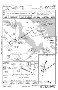
Communications frequencies: [VIEW]
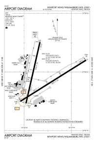
Runways:
| RWY identifier | QFU | Length (ft) | Width (ft) | Surface | LDA (ft) |
| 02 | 13° | 6526 | 150 | CONC | 6526 |
| 20 | 193° | 6526 | 150 | CONC | 6526 |
| 07 | 58° | 8003 | 150 | ASPH | 8003 |
| 25 | 238° | 8003 | 150 | ASPH | 8003 |
Airport contact information
Address: Newport News United States
