


KPHF - Newport News/Williamsburg Intl
Located in Newport News, United States
ICAO - PHF, IATA - PHF
Data provided by AirmateGeneral information
Coordinates: N37°7'55" W76°29'35"
Elevation is 42 feet MSL.
Magnetic variation is -09° East View others Airports in Virginia
Operational data
Special qualification required
Current time UTC:
Current local time:
Weather
METAR: KPHF 271054Z 08006KT 10SM SCT065 11/08 A3045 RMK AO2 SLP310 T01060078
TAF: KPHF 271120Z 2712/2812 10007KT P6SM BKN070 FM271300 12009KT P6SM BKN060 FM280000 15007KT P6SM BKN100 FM280600 19007KT P6SM SCT100
Communications frequencies: [VIEW]
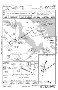
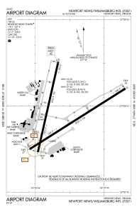
Runways:
| RWY identifier | QFU | Length (ft) | Width (ft) | Surface | LDA (ft) |
| 02 | 13° | 6526 | 150 | CONC | 6526 |
| 20 | 193° | 6526 | 150 | CONC | 6526 |
| 07 | 58° | 8003 | 150 | ASPH | 8003 |
| 25 | 238° | 8003 | 150 | ASPH | 8003 |
Airport contact information
Address: Newport News United States
