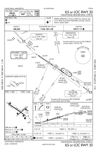
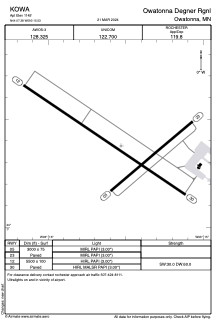


KOWA - Owatonna Degner Rgnl
Located in Owatonna, United States
ICAO - OWA, IATA -
Data provided by AirmateGeneral information
Coordinates: N44°7'23" W93°15'32"
Elevation is 1145 feet MSL.
Magnetic variation is 02° East View others Airports in Minnesota
Operational data
Special qualification required
Current time UTC:
Current local time:
Weather
METAR: KOWA 020233Z AUTO 00000KT 10SM OVC100 14/07 A2997 RMK AO2
Communications frequencies: [VIEW]
Runways:
| RWY identifier | QFU | Length (ft) | Width (ft) | Surface | LDA (ft) |
| 05 | 50° | 3000 | 75 | ASPH | |
| 23 | 230° | 3000 | 75 | ASPH | |
| 12 | 124° | 5500 | 100 | CONC | |
| 30 | 304° | 5500 | 100 | CONC |
Airport contact information
Address: Owatonna United States