


KONL - The O'neill Muni-John L Baker Fld
Located in O'neill, United States
ICAO - ONL, IATA -
Data provided by AirmateGeneral information
Coordinates: N42°28'10" W98°41'16"
Elevation is 2033 feet MSL.
Magnetic variation is 09° East View others Airports in Nebraska
Operational data
Special qualification required
Current time UTC:
Current local time:
Weather
METAR: KONL 290235Z AUTO 31011G15KT 10SM RA SCT019 SCT038 OVC075 07/05 A2981 RMK AO2 T00660046
Communications frequencies: [VIEW]
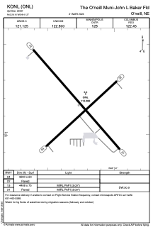
Runways:
| RWY identifier | QFU | Length (ft) | Width (ft) | Surface | LDA (ft) |
| 04 | 48° | 3200 | 60 | CONC | |
| 22 | 228° | 3200 | 60 | CONC | |
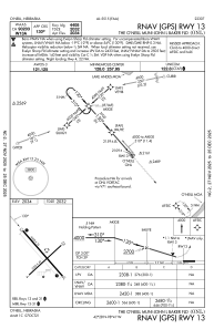
| 13 | 139° | 4408 | 75 | CONC | |
| 31 | 319° | 4408 | 75 | CONC |
Airport contact information
Address: O'neill United States