


KNSE - Whiting Fld Nas North
Located in Milton, United States
ICAO - NSE, IATA -
Data provided by AirmateGeneral information
Coordinates: N30°43'21" W87°1'26"
Elevation is 199 feet MSL.
Magnetic variation is -02° East View others Airports in Florida
Operational data
Special qualification required
Current time UTC:
Current local time:
Weather
TAF: TAF COR KNSE 0215/0315 VRB05KT 9999 SCT008 BKN250 QNH2995INS TEMPO 0215/0216 BKN007 FM021700 18012G18KT 9999 SCT020 SCT060 BKN250 QNH2989INS FM030100 16006KT 9999 SCT070 SCT130 BKN250 QNH2992INS FM030500 VRB04KT 8000 BR SCT008 BKN130 OVC250 QNH2988INS FM031000 VRB02KT 4800 BR BKN002 BKN008 QNH2989INS TEMPO 0310/0313 0800 FG OVC002 FM031300 14006KT 8000 BR SCT004 SCT015 BKN130 BKN250 QNH2996INS TX29/0218Z TN20/0312Z COR 1513 FN20071
Communications frequencies: [VIEW]
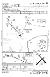
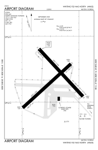
Runways:
| RWY identifier | QFU | Length (ft) | Width (ft) | Surface | LDA (ft) |
| 05 | 47° | 6003 | 200 | ASPH | |
| 23 | 227° | 6003 | 200 | ASPH | |
| 14 | 137° | 6001 | 200 | ASPH | |
| 32 | 317° | 6001 | 200 | ASPH |
Airport contact information
Address: Milton United States