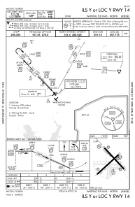
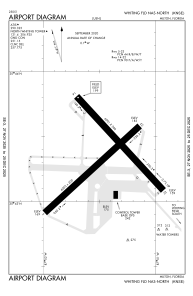


KNSE - Whiting Fld Nas North
Located in Milton, United States
ICAO - NSE, IATA -
Data provided by AirmateGeneral information
Coordinates: N30°43'21" W87°1'26"
Elevation is 199 feet MSL.
Magnetic variation is -02° East View others Airports in Florida
Operational data
Special qualification required
Current time UTC:
Current local time:
Weather
METAR: KNSE 020056Z 18006KT 10SM SCT110 22/20 A2993 RMK AO2 SLP122 T02220200 $
TAF: TAF KNSE 0123/0223 16007KT 9999 FEW060 SCT100 SCT250 QNH2989INS TEMPO 0204/0207 VRB05KT 8000 BR BKN005 FM020700 00000KT 3200 BR OVC005 QNH2992INS TEMPO 0207/0212 0800 FG OVC002 FM021300 12007KT 9999 SCT015 SCT250 QNH2995INS FM021800 17012G18KT 9999 SCT025 SCT150 BKN250 QNH2992INS AUTOMATED SENSOR METWATCH 0204 TIL 0211 TX29/0219Z TN19/0209Z FN20029
Communications frequencies: [VIEW]
Runways:
| RWY identifier | QFU | Length (ft) | Width (ft) | Surface | LDA (ft) |
| 05 | 47° | 6003 | 200 | ASPH | |
| 23 | 227° | 6003 | 200 | ASPH | |
| 14 | 137° | 6001 | 200 | ASPH | |
| 32 | 317° | 6001 | 200 | ASPH |
Airport contact information
Address: Milton United States