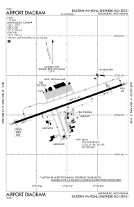


KMRB - Eastern Wv Rgnl/Shepherd Fld
Located in Martinsburg, United States
ICAO - MRB, IATA - MRB
Data provided by AirmateGeneral information
Coordinates: N39°24'8" W77°58'59"
Elevation is 564 feet MSL.
Magnetic variation is -08° East View others Airports in West Virginia
Operational data
Special qualification required
Current time UTC:
Current local time:
Weather
METAR: KMRB 061953Z VRB03KT 10SM OVC017 21/17 A2992 RMK AO2 SLP130 T02110167
TAF: KMRB 061731Z 0618/0718 05003KT P6SM OVC013 FM062200 09004KT 6SM -SHRA VCTS OVC050CB FM070300 10002KT 5SM -SHRA BR OVC015 FM070800 00000KT 2SM BR OVC007 FM071400 08002KT P6SM BKN015 FM071700 23003KT P6SM BKN030
Communications frequencies: [VIEW]
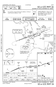
Runways:
| RWY identifier | QFU | Length (ft) | Width (ft) | Surface | LDA (ft) |
| 08 | 71° | 8815 | 150 | OTHER | 8215 |
| 26 | 251° | 8815 | 150 | OTHER | 7815 |
Airport contact information
Address: Martinsburg United States
