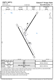


KMPV - Edward F Knapp State
Located in Barre/Montpelier, United States
ICAO - MPV, IATA - MPV
Data provided by AirmateGeneral information
Coordinates: N44°12'13" W72°33'44"
Elevation is 1165 feet MSL.
Magnetic variation is -16° East View others Airports in Vermont
Operational data
Special qualification required
Current time UTC:
Current local time:
Weather
METAR: KMPV 061851Z AUTO 33007G15KT 10SM CLR 21/08 A2992 RMK AO2 SLP133 T02060078
TAF: KMPV 061720Z 0618/0718 33006KT P6SM FEW035 FM070200 00000KT P6SM SKC FM070800 00000KT 2SM BR SCT002 FM071300 33005KT P6SM SKC
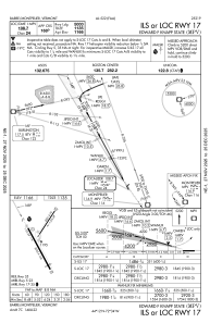
Communications frequencies: [VIEW]
Runways:
| RWY identifier | QFU | Length (ft) | Width (ft) | Surface | LDA (ft) |
| 05 | 32° | 3001 | 75 | ASPH | |
| 23 | 212° | 3001 | 75 | ASPH | |
| 17 | 152° | 5000 | 100 | ASPH | |
| 35 | 332° | 5000 | 100 | ASPH |
Airport contact information
Address: Barre/Montpelier United States
